Why Hike the Ruta del Cares?
The Ruta del Cares, located in the Picos de Europa—a compact mountain range spanning Asturias, Cantabria, and León—is a bucket-list hike for its stunning scenery and accessibility. Carved into the cliffs in the early 20th century to maintain a hydroelectric canal, the trail offers a relatively flat path, making it suitable for various fitness levels, though its narrow sections and heights require caution. June’s mild weather (15–20°C) and longer daylight hours make it an ideal time to hike, with fewer crowds than peak summer. The trail’s dramatic gorge, frequent goat sightings, and proximity to charming villages like Poncebos and Caín make it a perfect blend of nature and culture, ideal for a day trip or part of a Picos road trip.
Pre-Hike Planning: Essentials for Success
Before setting out, thorough preparation ensures a safe and enjoyable experience. Here’s what you need to know:
- Getting There: Start at Poncebos, Asturias, the most common trailhead, accessible by car from Santander (1.5 hours) or Oviedo (1.8 hours). Rent a car from Centauro or Avis at Santander Airport. Parking at Poncebos is limited (50–70 spaces), so arrive before 9 AM. Alternatively, take a taxi from Arenas de Cabrales (€10–15).
- Timing: The full 22-km round trip (Poncebos to Caín and back) takes 5–7 hours, including breaks. For a shorter hike, turn back after 6 km at the first viewpoint (3 hours round trip). Start by 10 AM to avoid midday heat and secure parking.
- Gear: Wear sturdy hiking boots with good grip, as the path is rocky in places. Bring a waterproof jacket, layers, a hat, sunscreen, and at least 2 liters of water per person. Pack snacks or a packed lunch, as refreshment stands are seasonal and unreliable.
- Navigation: The trail is well-marked with no forks, so a physical map isn’t essential, but download an offline map via AllTrails or Maps.me for reassurance. No GPS is needed due to the linear path.
- Safety: Check weather forecasts via Metservice, as rain or mist can make the trail slippery. Avoid hiking during heavy rain due to rockfall risks. The trail has exposed sections with 100-meter drops; those with vertigo should reconsider or stick to the first 6 km.
- Permits: No permits are required, as the trail is within a national park with free access.
- Cost: Budget €10–20 for fuel or taxis, €5–10 for snacks, and €0 for entry. Accommodation in Poncebos or Arenas de Cabrales ranges from €60–100/night.
Trail Overview and Map Description
The Ruta del Cares is a linear, out-and-back trail stretching 11 km one-way from Poncebos (Asturias) to Caín (León), totaling 22 km round trip. Here’s a detailed breakdown, with a conceptual map to guide you:
- Starting Point: Poncebos (250 m elevation)
The trail begins at a small parking lot near Hostal Poncebos, marked by a signboard. The path starts with a 2-km ascent, gaining 300 m, the steepest section. This rocky, shaded climb offers early views of the Cares River below. - Km 2–6: Entering the Gorge
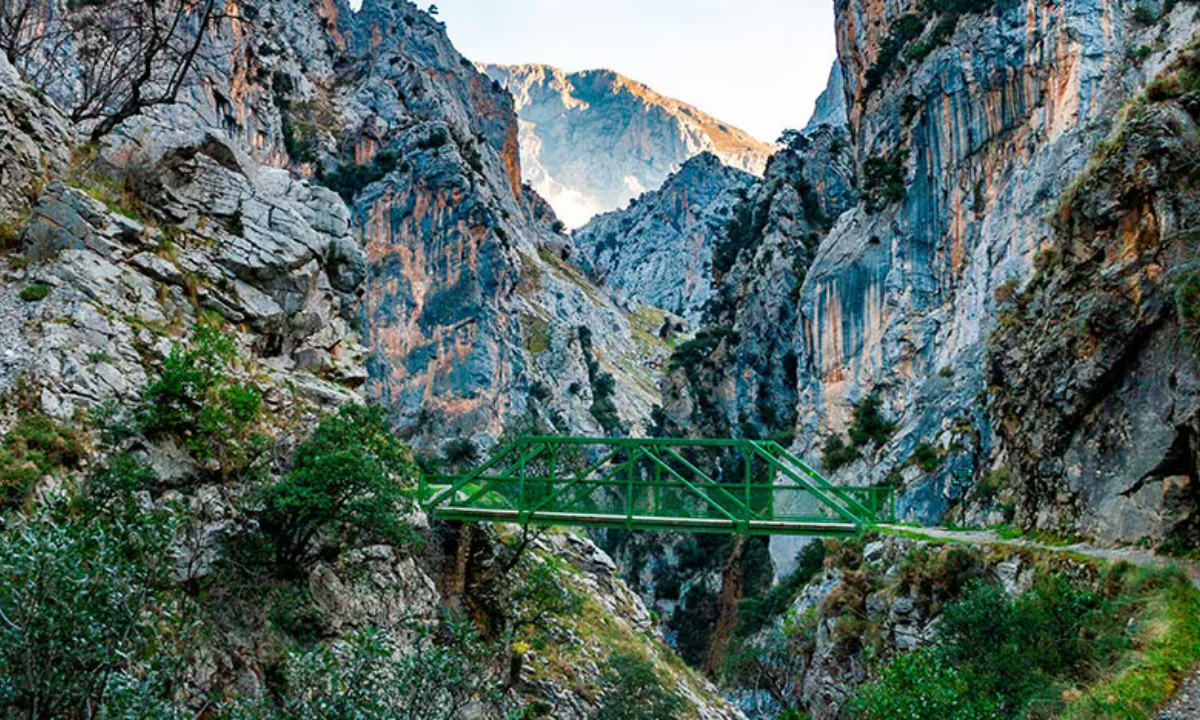
After the initial climb, the trail levels out, hugging the cliffside with a gentle descent. The path narrows to 1–2 meters in places, with guardrails in some sections but exposed drops in others. Pass through short tunnels carved into the rock and cross wooden bridges. At km 6, a viewpoint offers panoramic gorge views—ideal for photos or a turnaround point for a shorter hike (12 km round trip). - Km 6–9: Heart of the Canyon
The trail continues along the canal, with the Cares River’s turquoise waters sparkling below. Look for wild goats scaling the cliffs and eagles overhead. The path remains flat, passing small waterfalls and stone walls. This section is the most scenic, with towering limestone peaks like Peña Maín looming above. - Km 9–11: Descent to Caín
The trail gradually descends toward Caín, a tiny village in León. Cross the Bolín and Culiembro bridges, where the gorge widens slightly. Arrive in Caín, a cluster of stone houses with a few cafés and restaurants. Rest here before the return journey. - Return Journey (11 km)
Retrace your steps to Poncebos, as there’s no loop option. The return feels faster due to familiarity, but the initial 2-km descent from Caín requires care. Total elevation gain is ~500 m round trip.
Conceptual Map:
- 0 km: Poncebos (parking, trailhead sign)
- 2 km: End of ascent, first views
- 6 km: Main viewpoint (turnaround for short hike)
- 9 km: Bolín Bridge, open gorge
- 11 km: Caín (rest, cafés)
- 11–22 km: Return to Poncebos
Step-by-Step Hiking Instructions
Follow these steps for a safe and enjoyable hike:
Step 1: Arrive and Prepare
Reach Poncebos by 9 AM to secure parking near Hostal Poncebos or along the AS-264 road. Use the public restroom at the trailhead, as facilities are scarce. Fill water bottles, apply sunscreen, and check your gear. Take a photo of the trailhead sign for reference.
Step 2: Tackle the Initial Ascent (0–2 km, 45 minutes)
Start at the trailhead, following the clear path uphill. The 2-km climb is steady but manageable, with switchbacks through shaded forest. Pause at viewpoints to catch your breath and snap photos of the Cares Valley. Reach the high point (550 m) marked by a stone bench.
Step 3: Enter the Gorge (2–6 km, 1–1.5 hours)
The trail flattens, transitioning to a cliffside path carved into the rock. Walk single-file in narrow sections, yielding to oncoming hikers. Pass through short tunnels and over bridges, keeping right to avoid drops. At km 6, stop at the viewpoint for photos of the gorge’s dramatic cliffs. If opting for a shorter hike, turn back here (3 hours total).
Step 4: Explore the Heart of the Canyon (6–9 km, 1 hour)
Continue along the flat, scenic path, marveling at the river below and peaks above. Watch for goats and listen for the river’s rush. The trail remains narrow but safe with careful footing. Take breaks at wider sections to hydrate and snack. Cross small streams trickling from the cliffs.
Step 5: Reach Caín (9–11 km, 45 minutes)
Descend gently toward Caín, crossing the Bolín and Culiembro bridges. The gorge widens, revealing Caín’s stone houses. Rest at a café like Bar La Ruta, enjoying a €5 sandwich or coffee. Use the restroom and refill water if needed. Spend 30–60 minutes relaxing before the return.
Step 6: Return to Poncebos (11–22 km, 2.5–3 hours)
Retrace your steps, starting with a gentle climb from Caín. The return feels quicker, but stay alert on narrow sections. The final 2-km descent to Poncebos is steep, so use trekking poles if you have them. Arrive back by late afternoon, celebrating with a cider at Hostal Poncebos.
Safety and Etiquette Tips
- Weather Awareness: June is mild, but sudden mists or rain can make the trail slippery. Check Metservice and avoid hiking if storms are forecast. Carry a waterproof jacket.
- Vertigo Caution: The trail has exposed drops (up to 100 m). If prone to vertigo, stick to the first 6 km or consider an alternative like the Covadonga Lakes trail.
- Trail Etiquette: Yield to uphill hikers and those returning from Caín. Keep noise low to respect wildlife and other hikers. Pack out all trash.
- Wildlife: Wild goats are common and harmless but don’t feed them. Spanish mastiffs may guard livestock; keep your distance.
- Emergency Prep: Cell service is spotty. Carry a first-aid kit and know the emergency number (112). Inform someone of your plans.
Cultural and Culinary Context
The Ruta del Cares lies in the Picos de Europa, a region steeped in history. The trail was built in 1916–1945 to maintain a hydroelectric canal, now a testament to human ingenuity. Nearby Arenas de Cabrales is famous for Queso Cabrales, a pungent blue cheese aged in caves—visit one for €5. After hiking, sip Asturian sidra (cider) poured from a height, a local tradition. Dine at La Soldreria in Arenas for fabada (bean stew) or cachopo (stuffed veal). On X, hikers share photos of the gorge’s cliffs, praising its raw beauty and the charm of nearby villages.
Practical Tips for a Seamless Hike
- Accommodation: Stay in Poncebos (Hostal Poncebos, €60/night) or Arenas de Cabrales (Hotel Picos de Europa, €80/night). Book via Booking.com for June availability.
- Transport Options: If not returning to Poncebos, arrange a taxi from Caín to Poncebos (€50–70, book via local hotels). Public buses from Arenas to Cangas de Onís are limited.
- Post-Hike: Relax in Arenas with a cheese-tasting tour or visit Bulnes (10-minute drive) via funicular for village charm.
- Language: English is limited in rural Asturias. Use Google Translate for menus or learn phrases like “¿Dónde está el sendero?” (Where is the trail?).
Why This Guide Works
This guide provides a detailed, step-by-step plan for hiking the Ruta del Cares, tailored for June 2025. It balances practical instructions with cultural insights, ensuring you’re prepared for the trail’s challenges and rewards. The conceptual map and safety tips cater to both novice and experienced hikers, while the focus on local cuisine and nearby attractions enhances your Picos experience. Whether you’re hiking the full 22 km or a shorter 12 km, this guide equips you to navigate the Divine Gorge with confidence.
Conclusion: Your Ruta del Cares Adventure Awaits
The Ruta del Cares is a journey through one of Spain’s most dramatic landscapes, offering stunning views, rich history, and a taste of Asturian culture. This comprehensive guide, crafted for Karachi travelers at 11:29 AM PKT, equips you with everything needed to hike the trail in June 2025—from preparation and navigation to safety and local tips. Whether marveling at the Cares Gorge, sipping cider in Caín, or spotting goats on the cliffs, this hike will leave you awestruck. Pack your gear, book your stay, and hit the trail. For more inspiration, check out hiker reviews on X or visit picosdeeuropa.com. Your adventure in the Divine Gorge starts now—happy hiking!