The Ruta del Cares, often called the “Divine Gorge,” is one of Spain’s most spectacular hiking trails, winding through the heart of Picos de Europa National Park. This 12km (7.5-mile) path, carved into limestone cliffs above the Cares River, connects the villages of Poncebos (Asturias) and Caín (León), offering breathtaking views of towering peaks, narrow gorges, and cascading waterfalls. Known as PR-PNPE 3, the trail’s dramatic scenery and moderate difficulty make it a bucket-list adventure for hikers worldwide. In 2025, with improved access and sustainable tourism measures, it’s the perfect time to explore this iconic route. This 2,000-word guide, informed by sources like Anywhere We Roam, Spain.info, and posts on X, provides a detailed map, step-by-step instructions, safety tips, and practical advice for hiking the Ruta del Cares. Whether you’re a seasoned trekker or a first-time visitor, here’s everything you need to plan an unforgettable journey.
Why Hike the Ruta del Cares?
The Ruta del Cares is a marvel of nature and engineering, originally built between 1916 and 1921 to maintain a hydroelectric canal and later expanded in the 1940s. Stretching along a gorge flanked by 2,000m cliffs, it’s dubbed “La Garganta Divina” for its awe-inspiring beauty. Lonely Planet calls it “one of Spain’s most arresting trails,” while X user @TravelSpain enthuses, “The views from Ruta del Cares are unreal—worth every step!” With minimal elevation gain (200m), the trail is accessible yet thrilling, passing through tunnels, over bridges like Puente de Los Rebecos, and alongside mountain goats. Its 300,000 annual visitors attest to its popularity, yet strategic planning ensures a serene experience. This guide covers the standard 22–24km out-and-back hike, with options for shorter or one-way treks.
Is the Ruta del Cares Safe in 2025?
Spain ranks 29th in the 2024 Global Peace Index, and Picos de Europa is a low-crime area, making the trail safe for hikers. The U.S. State Department rates Spain as Level 2 (exercise increased caution) due to general tourism risks like pickpocketing, but no specific concerns apply to this remote region. The trail itself poses moderate risks: uneven terrain, narrow sections (1–3m wide), and sheer drop-offs without guardrails. Anywhere We Roam notes it’s “safe with caution, even for those with mild vertigo.” X user @HikeEurope advises, “Stick to the wall side and watch your step—gorgeous but no place for distraction.” Recent trail maintenance and regulated parking enhance safety.
Key Safety Tips
- Terrain Awareness: Rocky paths and polished surfaces can be slippery when wet. Wear sturdy hiking boots with good grip.
- Weather Preparedness: Weather shifts rapidly (5–25°C in spring/fall; hotter in summer). Pack a waterproof jacket and warm layers. Avoid hiking during heavy rain or snow due to rockfall risks.
- Vertigo Caution: Narrow sections with 500m drops may unsettle those with height fears. Walk close to the cliff wall.
- Emergency Prep: Mobile coverage is spotty; carry a charged phone for 112 (emergency service). Inform someone of your plans.
- Hydration and Nutrition: No facilities exist on the trail. Bring 2L water and high-energy snacks (nuts, bananas).
- Group Hiking: Solo hiking is fine, but groups enhance safety. Guided tours via Frontera Verde ($50–$80) offer expert support.
Planning Your Hike
Best Time to Hike
The Ruta del Cares is open year-round, but weather and crowds vary:
- Spring (April–May): Mild temperatures (10–20°C), blooming wildflowers, and moderate crowds. Moonhoneytravel praises late May for “perfect conditions.”
- Autumn (September–October): Clear skies, cooler weather (8–18°C), and fewer hikers. Ideal for photography, per Much Better Adventures.
- Summer (June–August): Warm (20–30°C) but crowded, especially during Easter and August. Start early to avoid heat and congestion.
- Winter (November–March): Risky due to snow, ice, and reduced daylight. Only for experienced hikers with proper gear.
Entry Requirements
- Visa: U.S., Canadian, and EU citizens need no visa for Spain (Schengen Area, 90-day stay). Others may require a Schengen visa via iVisa.
- Permits: No permits needed for the trail, but parking restrictions apply in high season (see below).
- Health: No vaccinations required. Travel insurance (e.g., SafetyWing, $40–$80) is recommended for medical emergencies.
Getting There
- By Air: Fly into Santander (SDR), Asturias (OVD), or Bilbao (BIO) airports. From the U.S., round-trip fares cost $500–$1,200. Rent a car via Rentalcars.com ($30–$50/day).
- To Poncebos: From Santander (120km, 2h drive), take AS-114 to Las Arenas de Cabrales, then AS-264 for 5km. Parking is limited; use Ovar lot (1.2km from trailhead, $2–$5) or shuttle from Las Arenas ($3 round-trip, 8 AM–7 PM, per Turismo Asturias).
- To Caín: From León (140km, 2.5h), take N-625 to Riaño, then LE-2711 to Posada de Valdeón and Caín. Parking is easier but limited; arrive by 8 AM, per Tripadvisor.
- Public Transport: Buses (ALSA) connect Santander to Las Arenas ($10, 2h). From there, take a taxi ($15–$20) or shuttle to Poncebos. No direct buses to Caín.
Getting Around
- Trailhead Access: Poncebos trailhead is a 10-minute walk from the village. Caín’s trailhead is at the gorge entrance.
- Return Options: The trail is out-and-back (22–24km). For one-way hikes, book a taxi ($100–$150, 2h from Caín to Poncebos) or 4×4 tour ($50–$80 via Ruta del Cares 4×4).
- Biking: Prohibited for safety, per Valledevaldeon.es.
Budgeting for the Hike
The Ruta del Cares is budget-friendly, with costs driven by transport and accommodation. Daily expenses range from $50–$150 per person.
Sample Budget
- Transport: Car rental ($30–$50/day), parking ($2–$5), or shuttle ($3). Taxi return: $100–$150.
- Accommodation: Hostels ($20–$40/night, e.g., Hostal La Ruta in Caín); hotels ($50–$100, e.g., Arcea Mirador de Cabrales in Poncebos).
- Food: Picnic supplies ($5–$10); meals in Caín/Poncebos ($8–$15, e.g., fabada or Valdeón blue cheese).
- Activities: Free trail access; optional guided tours ($50–$80).
- Total: $50–$100/day (budget); $100–$150/day (mid-range, with taxi).
Money Tips
- Currency: Euro (€). Cards are accepted in Las Arenas; carry €20–€50 cash for Caín.
- ATMs: Available in Las Arenas; scarce in Caín/Poncebos.
- Tipping: Optional (5–10% at restaurants).
- Savings: Book accommodations early via Booking.com for discounts. Pack meals to avoid pricey village cafes.
Trail Overview and Map
Distance: 12km one-way (24km round-trip)
Duration: 3–3.5h one-way; 6–7h round-trip
Elevation Gain: ~200m (minimal after initial climb from Poncebos)
Difficulty: Moderate (length and exposure; no technical skills needed)
Trail Type: Out-and-back
Map: Google Maps link or download via AllTrails for offline use.
Trail Map Description
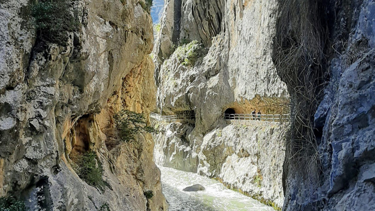
The Ruta del Cares follows a well-marked path along the Cares River, carved into the western (Cornión) and central (Urrieles) massifs. Starting from Poncebos, the trail ascends 2km steeply, then levels out, hugging cliffs with tunnels, bridges (Bolín, Los Rebecos), and caves. Near Caín, the gorge narrows, with waterfalls and lush greenery. Key waypoints:
- Poncebos Trailhead: 10-minute walk from village, near Bar Poncebos.
- Los Collaos: Highest point, 3km from Poncebos, with views of Mount Urriellu.
- Bolín Bridge: 8km from Poncebos, 60m long, crossing the river.
- Los Rebecos Bridge: 8.4km, iconic green bridge, highly photogenic.
- Caín: End point, with cafes and river pools.
Navigation Tip: The trail is clear and impossible to lose, per Moonhoneytravel. Carry a map (AllTrails or Komoot) for reference, as mobile signal is weak.
Step-by-Step Hiking Instructions
Starting from Poncebos (Recommended)
- Preparation: Arrive by 8 AM to secure parking or take the shuttle. Pack 2L water, snacks, sunscreen, and a raincoat. Wear hiking boots.
- Trailhead: From Poncebos, walk 10 minutes along the main road (AS-264), keeping the Cares River on your left. Pass Puente La Jaya (leads to Bulnes; ignore). At the information booth, turn right onto the signed “Senda del Cares / Caín” path (PR-PNPE 3).
- First 2km (0–45 min): Ascend a steep, cobbled path (200m gain) through rocky terrain. Pass a falling rocks sign. Views of limestone peaks emerge. Pace yourself; this is the toughest section.
- 2–8km (45 min–2h): The trail levels at Los Collaos, offering panoramic views. Follow the flat, 1–3m-wide path carved into cliffs. Pass small caves and the canal (non-drinkable water). Spot goats and vultures. The gorge widens, with Mount Urriellu visible on clear days.
- 8–12km (2–3.5h): Cross Bolín Bridge (60m), then Los Rebecos Bridge. Enter tunnels (some wet; watch your head). The gorge narrows, with waterfalls and greenery. Descend slightly to Caín, arriving at the village’s gorge entrance.
- In Caín: Rest at cafes (try cachopo, $10–$15) or dip in river pools (cold!). For round-trip, retrace steps (2.5–3h back, faster downhill). For one-way, arrange a taxi/4×4.
- Return (Round-Trip): The return feels easier, with new perspectives. Start back by 3 PM to finish before dark. Total: 6–7h.
Starting from Caín (Alternative)
- Why Choose Caín?: Narrower gorge, more tunnels/bridges, and fewer hikers early, per Roads-and-Rivers. Ideal for shorter hikes (e.g., 4–6km out-and-back).
- Instructions: Park in Caín by 8 AM (easier than Poncebos). Start at the gorge entrance. The trail is flat, following the river closely. Pass tunnels and Los Rebecos Bridge early. Turn back at Culiembro (hut, 5km) for a shorter hike or continue to Poncebos (3–3.5h). Return or book transport.
- Note: Caín’s section is more dramatic but less accessible by public transport.
Must-Know Trail Highlights
- Puente de Los Rebecos: A green bridge at 8.4km, framed by cliffs, is Instagram-famous. Much Better Adventures calls it “northern Spain’s most photographed spot.”
- Tunnels and Caves: Near Caín, 71 hand-carved tunnels add adventure. Some drip water; bring a headlamp for fun.
- Mountain Goats: Friendly goats roam cliffs, unbothered by hikers. Keep distance to avoid rockfalls.
- Los Collaos Viewpoint: At 3km from Poncebos, spot Mount Urriellu (Naranjo de Bulnes), a 500m climbing icon.
- Cares River: Its turquoise waters, 500m below, create a hypnotic backdrop. Spain.info highlights bridges like Bolín for dizzying views.
Accommodation and Food
Where to Stay
- Poncebos:
- Las Arenas de Cabrales (5km away):
- Caín:
- Booking Tip: Reserve 3–6 months ahead for summer/Easter via Booking.com. Stay in Poncebos for convenience.
What to Eat
- On Trail: Pack a picnic (sandwiches, nuts, fruit; $5–$10 from Las Arenas markets). No facilities en route.
- In Caín/Poncebos:
- Tips: Eat a big breakfast (most hotels include). In Caín, Restaurante El Dobra offers affordable meals ($10–$15).
Packing Essentials
- Footwear: Hiking boots (e.g., Salomon X Ultra) for rocky terrain.
- Clothing: Moisture-wicking layers, waterproof jacket, hat, sunglasses. Sunscreen (SPF 50) for exposed sections.
- Gear: 2L water bottle, high-energy snacks, map (AllTrails/Komoot), phone, power bank, small first-aid kit.
- Optional: Binoculars for wildlife, camera with zoom lens, headlamp for tunnels.
- Guidebook: Lonely Planet Spain or Cicerone Picos de Europa for regional hikes.
Cultural and Practical Tips
- Language: Spanish is dominant; basic English is spoken in Las Arenas. Learn “hola” and “gracias” to connect.
- Etiquette: Yield to uphill hikers on narrow sections. Don’t disturb goats or litter (pack out all waste).
- Crowds: High season (July–August) sees 300,000 hikers. Start at 7–8 AM to avoid congestion.
- Sustainability: Follow Leave No Trace principles. Use shuttles to reduce traffic, per Turismo Asturias.
- Photography: Wide-angle lenses capture the gorge’s scale. Avoid drones (prohibited in national park).
Sample Itinerary
Day 1: Arrive in Las Arenas/Poncebos
- Check into Arcea Mirador de Cabrales. Explore Las Arenas; try Cabrales cheese. Sleep early.
Day 2: Hike Ruta del Cares
- 7 AM: Breakfast, drive/shuttle to Poncebos.
- 8 AM: Start hike. Reach Caín by noon. Lunch ($10–$15).
- 1 PM: Return hike. Finish by 4–5 PM.
- Evening: Dinner in Las Arenas (fabada, $8–$12). Overnight.
Day 3: Depart or Explore
- Visit Bulnes (1.5h hike from Poncebos) or Cangas de Onís. Depart via Santander.
Budget: $150–$250 for 2 nights, hike, meals, transport (excluding flights).
Pros and Cons
Pros
- Stunning Scenery: Limestone peaks, bridges, and tunnels create unforgettable views.
- Accessible: Moderate difficulty suits most hikers; well-marked trail.
- Budget-Friendly: Low costs for trail access and meals.
- Wildlife: Goats, vultures, and flora enhance the experience.
Cons
- Crowds: Summer/Easter congestion can disrupt tranquility.
- Length: 22–24km round-trip is tiring; one-way requires costly transport.
- Exposure: No guardrails and narrow paths may unnerve some.
- No Facilities: Requires self-sufficiency for water/food.
Final Thoughts
The Ruta del Cares is more than a hike—it’s a journey through Spain’s wild heart. Its dramatic gorge, carved by the Cares River and framed by Picos de Europa’s limestone giants, delivers a thrill that Anywhere We Roam calls “one of Europe’s best day hikes.” With clear instructions, a reliable map, and practical tips, this 2025 guide ensures you’re ready for the 22–24km adventure. Start early, pack wisely, and savor highlights like Los Rebecos Bridge and mountain goats. As X user @HikeEurope puts it, “Ruta del Cares is Spain’s hiking gem—don’t miss it!” Whether from Poncebos or Caín, this trail promises memories that linger long after your boots hit the path.
Plan now: book your stay, check shuttle schedules, and prepare for the Divine Gorge. The Picos de Europa await.